Montville Township Historical Society
Unlocking History, Embracing Community
Montville Township History


Pre-Montville
Montville Township has a rich history dating back to its time as part of the New Netherland colony from 1624 to 1664. In 1694, Arent Schuyler orchestrated an investment by seven influential individuals to acquire the land known as Pompton Valley. Schuyler negotiated with the Indians for the area's Indian Rights, while Samuel Bayard handled dealings with the East Jersey Company, holding land rights from the King of England. The purchase, known as the Pequannock Patent, encompassed what is now Bloomingdale, Boonton, Boonton Township, Butler, Denville, Jefferson, Kinnelon, Lincoln Park, Montville, Riverdale, Rockaway Township, Wharton, Pequannock, and Wayne, concluding on November 1, 1695. In 1696, the same group made an additional purchase, establishing Pompton Plains. This led to the formation of Pequannock Township, one of the largest townships in New Jersey.
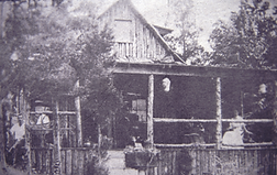
The area now known as Montville Township was first settled by Dutch farmers from New Amsterdam (now New York City) in the very early 18th century. Part of New Netherland, the town was originally called "Uyle-Kill" (the Dutch pronunciation of "Owl-Kill"), a name given to the creek and valley, which ran through the area. Montville faced challenges in the early 1700s, being a wilderness with trails connecting farms and mills accessible only on foot or horseback. Slowly evolving into a farming community. Montville's historical tapestry contained more than fifteen Dutch stone houses dating back to the 1700s, a unique feature shared by only three states - New York, Delaware, and New Jersey.
The first road (Rt 202) was laid out in 1745, followed by River Road in 1749. These roads connected various farms with essential facilities such as gristmills, sawmills, bark mills, and tanneries.
Military Route
During the Revolutionary War, Montville Township was on a major military route from Morristown to the Hudson River. General George Washington’s troops often took this route and Washington stayed in Montville Township (Towaco section) in June 1780. The French troops under the leadership of General Rochambeau also passed through Montville Township on their way to the War’s final victory at Yorktown, Virginia. It took them four days as they encompassed 5,000 soldiers, 2,000 horses, 500 oxen, possibly 900 cattle, artillery, boats, followers, etc.
How the Township Got Its Name
Montville was officially named with specific boundaries April 1800. The name came from the Mandeville Inn, which was pronounced Mondeveil by the Dutch. That name was corrupted to Montville. The Montville Inn is located at the site of the pre-Revolutionary War Mandeville Inn.
Post Revolutionary War Growth
The construction of the Morris Canal in this area was completed in 1828, bringing commercial navigation to the Montville / Towaco area. The mid-19th century saw the development of two smaller village centers set apart from Montville: Pine Brook, a fertile agricultural area in the Township’s southern end, and Towaco, situated on the Morris Canal. In 1867, the Township of Montville was formally chartered from 19 square miles of territory set off from what was part of Pequannock Township.
By the mid to late 1800s, Montville underwent a transformative phase, emerging as a thriving community boasting a post office, general stores, a canal, dwellings, cider mill, tannery, gristmill, school, church, and hotels. Notably, the completion of the Morris Canal in the mid-1800s, featured three incline planes which played a pivotal role in facilitating the transportation of farm goods to market and ore and wood to cities. The area, initially known as Uyle-Kill, officially became Montville on April 24, 1800, reflecting its historical roots derived from a store run by the Mandevilles. Montville Township, formed in 1867 from Pequannock, showcases diverse landscapes, with the southern part known for Pine Brook flats and central areas producing various agricultural products. This historical journey encompasses pivotal events like land purchases, road development, and the Morris Canal's impact, contributing to Montville's evolution from a wilderness to a thriving community.
Montville is Born
The Township of Montville is a municipal corporation which was established by special charter of the New Jersey State Legislature in 1867. The Township is a suburban community located in the County of Morris in the northwest portion of New Jersey. Montville Township is 20 square miles and comprised of 3 sections: Towaco, Pine Brook and Montville. There are approximately 20,000 residents. Montville is an active, vibrant community providing services, activities and volunteer opportunities in everything from sports and 4th of July celebrations to youth and senior groups.